• Menu
  • Skip to right header navigation
  • Skip to main content
  • Skip to primary sidebar
  • Skip to footer

Uncover Colorado Logo

  • Blog
  • Activities
    • Year-round
      • Brewery Tours
      • Casinos & Gaming
      • Colorado Brands
      • Federal Lands
      • Food & Dining
      • Ghost Towns
      • Gondola & Chairlifts
      • Hot Springs
      • Mine Tours
      • Museums
      • Paintball
      • Public Parks
      • Scenic Drives
      • Shopping
      • Sports Teams
      • State Parks
      • Train Rides
      • Transportation
      • Wildlife
      • Zip Lines & Aerial Parks
    • Spring, Summer & Fall
      • Amusement Parks
      • ATV Rentals
      • Biking
      • Boating
      • Camping
      • Drive-In Theaters
      • Fishing
      • Golf Courses
      • Hiking
      • Horseback Riding
      • Rock Climbing
      • Tubing & Paddling
      • Waterfalls
      • Whitewater Rafting
    • Winter
      • Cross Country Skiing
      • Dog Sledding
      • Ice Climbing
      • Ice Fishing
      • Ice Skating
      • Skiing & Snowboarding
      • Sleigh Rides
      • Snow Tubing
      • Snowmobiling
      • Snowshoeing
  • Events
    • January
    • February
    • March
    • April
    • May
    • June
    • July
    • August
    • September
    • October
    • November
    • December
  • Lodging
    • Budget Hotels
    • Historic Hotels
    • Luxury Hotels
    • Bed & Breakfasts
    • Cabins & Glamping
    • Casinos with Lodging
    • Dude Ranches
    • Hot Spring with Lodging
    • Wineries with Lodging
    • Campgrounds
  • Towns
  • Trip Planner
  • Search
  • Blog
  • Activities
  • Events
  • Lodging
  • Towns
  • Trip Planner
Marshall Pass, Colorado
Marshall Pass, Colorado. Photo: Larry Lamsa

Marshall Pass – Poncha Springs-Sargents

FacebookTwitter

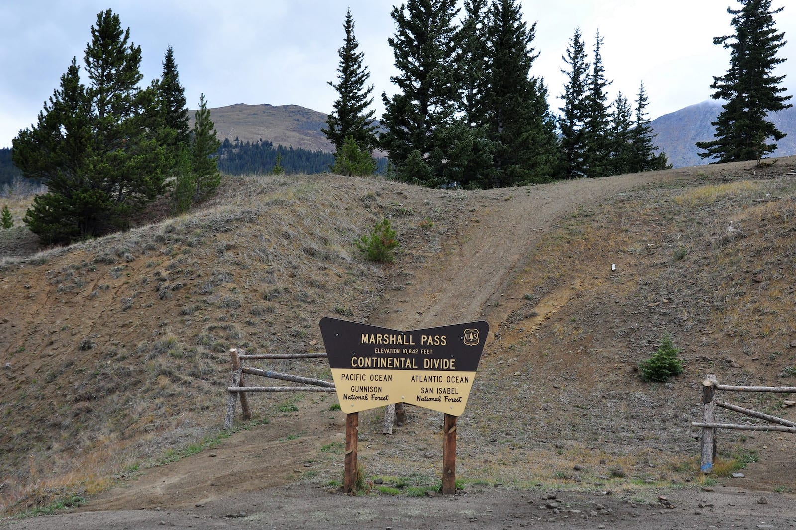
Along the Great Continental Divide, Marshall Pass sits at 10,842โ€™ between Sargents and Mears Junction, Colorado. If you are seeking a backcountry route between Salida and Gunnison, Marshall Pass Road offers amazing views and is accessible to most vehicles.

History

Marshall Pass, Colorado
Marshall Pass in 1899.

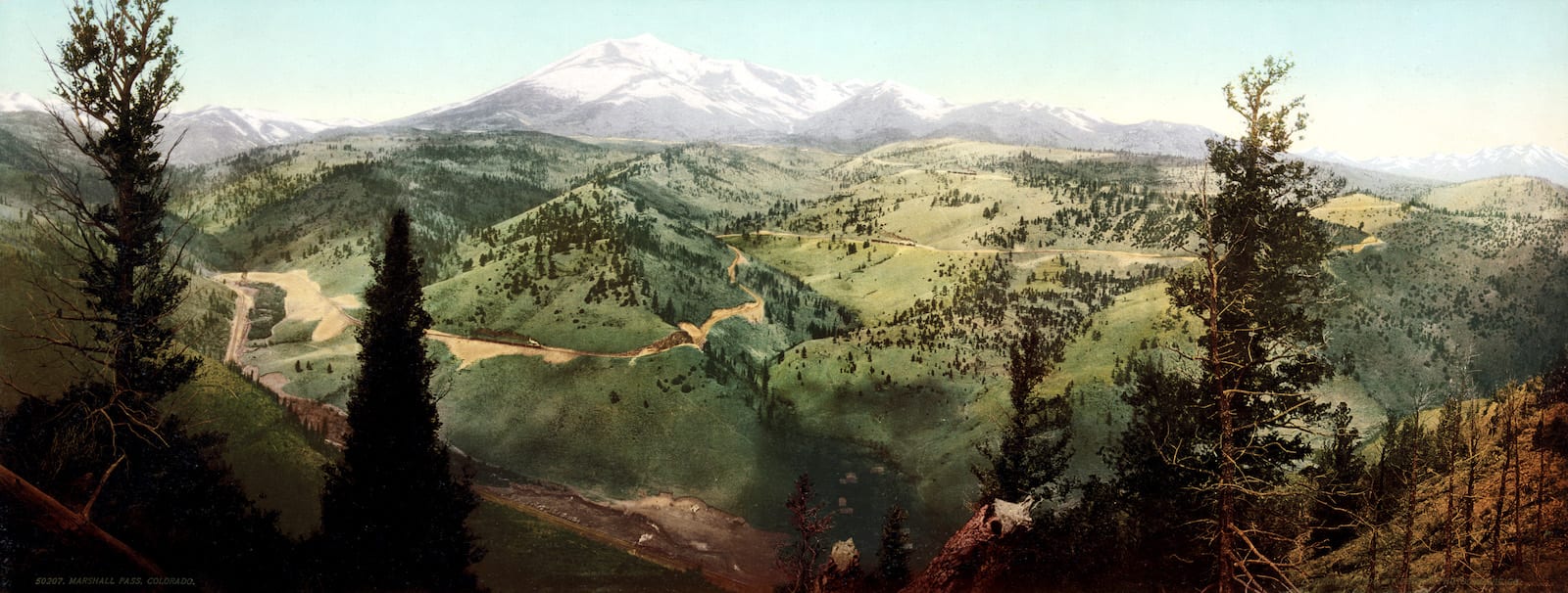
In 1873, Marshall Pass was discovered (and named for) Lt. William L Marshall. The surveyor deemed it a good spot for a road to traverse the continental divide. In 1880, a toll road was completed. Despite being incredibly steep, the toll provided stagecoach access between Gunnison, Coloraoย and the Arkansas River.

The very next year, a rail line was built across Marshall Pass, becoming the first railroad route to traverse the Continental Divide in Colorado. The railway was used heavily until it ultimately shut down in 1955. At its peak, the small settlement of Marshall, Pass Colorado had six buildings, 11 people, and what Time Magazine dubbed โ€œthe U.S.โ€™s smallest post office.โ€

Today, US 50 is the main route between Salida and Gunnison. Although Marshall Pass was considered to be along the route, the highway instead crosses the divide at Monarch Pass, a few miles north.

Marshall Pass Accessibility

Marshall Pass, Colorado
Marshall Pass sign, Colorado. Photo: Larry Lamsa

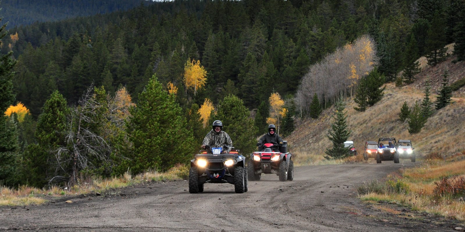
Passenger vehicles can access the 30-mile Marshall Pass Road in Sargents (off of US 50) or south of Poncha Springs (along highway 285). The gravel road follows the original railroad route, so it is not excessively steep. Although there are some rough patches along the way, most cars can easily traverse the pass in good conditions.

Seasonality – Marshall Pass is closed to vehicles in the winter. However, snowmobile and snowshoe traffic is allowed. Marshall Pass Road closes in the spring to prevent damage to the road.

Vehicle Restrictions – When the pass is free of snow (June through October), there are no vehicle restrictions on Marshall Pass Road. 2WD vehicles are generally okay when driving carefully.

Activities near Marshall Pass

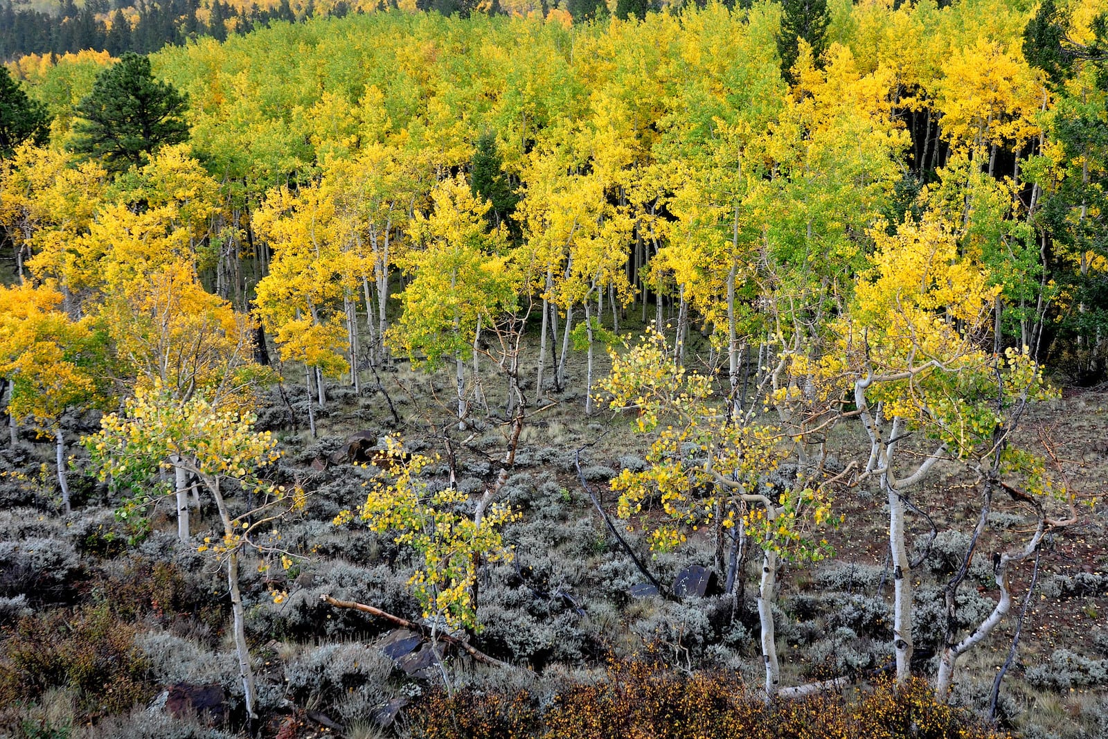
On both sides of the pass, there are many dispersed, primitive campsites in the Gunnison National Forest. The pass falls along the Colorado Trail and the nearby Marshall Pass Trail is also open to hikers and bikers. Marshall Pass Road travels directly through many aspen groves, making it a popular scenic byway for viewing fall colors.

Read about the Camping near Poncha Springs, around Marshall Pass.

Outside of Salida at Marshall Pass, Colorado
Outside of Salida at Marshall Pass, Colorado. Photo: Larry Lamsa

Details

Address: Marshall Pass Road, between Sargents and Mears Junction (near Poncha Springs)

Season: June through October

Elevation: 10,842 ft (3,305 m)

County: Saguache County

Mountain Range: Sawatch

Coordinates: 38ยฐ23’29.2″N 106ยฐ14’50.1″W

Access: Marshall Pass Road

Primary Sidebar

Join our Colorado travel community

Enter your email below and grab our free locals' guide and monthly what's up designed to help you live your Colorado life and uncover fun things to do. โ€”and never miss out again.

Recent Posts

  • Upcoming Spring Festivals in Colorado
  • 8 Great Springtime Colorado Festivals
  • 9 Colorado Ski & Snowboard Companies
  • Brief Timeline of Colorado’s Ski and Snowboard History
  • Fly Directly to these Colorado Ski Resorts with Airports Nearby

Footer

Get In Touch

  • Home
  • About Us
  • Contact Us
  • Privacy Policy
  • Resources
  • Disclaimer
Facebook Instagram Pinterest Twitter

Disclosure: Uncover Colorado is a participant in the Amazon Services LLC Associates Program, an affiliate advertising program designed to provide a means for sites to earn advertising fees by advertising and linking to Amazon.com.

Things To Do

  • Travel Blog
  • Colorado Activities
  • Colorado Events
  • Colorado Towns
  • Colorado Hotels
  • Colorado Restaurants
  • Colorado Transportation
  • Made in Colorado

Cheers! Mile High Happy Hour shares showcases Denver neighborhoods' restaurant happy hours.

Winter Activities

  • Federal Lands
  • Ghost Towns
  • Hot Springs
  • Ice Skating
  • Ski Resorts
  • Snow Tubing
  • State Parks
  • Train Rides

Copyright © 2023 ยท Uncover Colorado | Sitemap | Advertise