• Menu
  • Skip to right header navigation
  • Skip to main content
  • Skip to primary sidebar
  • Skip to footer

Uncover Colorado Logo

  • Blog
  • Activities
    • Year-round
      • Brewery Tours
      • Casinos & Gaming
      • Caves
      • Colorado Brands
      • Escape Rooms
      • Federal Lands
      • Food & Dining
      • Ghost Towns
      • Gondola & Chairlifts
      • Hot Springs
      • Lakes
      • Landmarks
      • Mine Tours
      • Mountains
      • Museums
      • Paintball
      • Performing Arts
      • Public Parks
      • Rivers
      • Scenic Drives
      • Sightseeing Tours
      • Shopping
      • Sports Teams
      • State Parks
      • Train Rides
      • Transportation
      • Winery Tours
      • Wildlife
      • Zip Lines & Aerial Parks
    • Spring, Summer & Fall
      • Amusement Parks
      • ATV Rentals
      • Biking
      • Boating
      • Camping
      • Drive-In Theaters
      • Fishing
      • Golf Courses
      • Hiking
      • Horseback Riding
      • Jeep Rentals
      • Rock Climbing
      • Tubing & Paddling
      • Waterfalls
      • Whitewater Rafting
    • Winter
      • Cross Country Skiing
      • Dog Sledding
      • Ice Climbing
      • Ice Fishing
      • Ice Skating
      • Skiing & Snowboarding
      • Sleigh Rides
      • Snow Tubing
      • Snowbiking
      • Snowmobiling
      • Snowshoeing
  • Events
    • January
    • February
    • March
    • April
    • May
    • June
    • July
    • August
    • September
    • October
    • November
    • December
  • Lodging
    • Budget Hotels
    • Historic Hotels
    • Luxury Hotels
    • Bed & Breakfasts
    • Boutique Hotels
    • Cabins & Glamping
    • Casinos w/ Lodging
    • Hot Spring w/ Lodging
    • Wineries w/ Lodging
    • Best Hotels
    • Dude Ranches
    • Campgrounds
  • Towns
  • Trip Planner
  • Search
  • Blog
  • Activities
  • Events
  • Lodging
  • Towns
  • Trip Planner
Route 62 Placerville Colorado
Route 62 northeast of Placerville. Photo: John Weiss

Placerville, Colorado

FacebookTwitter

Placerville is a tiny, unincorporated community on the road to Telluride. Only covering about 480 acres of land, it sits on the banks of the San Miguel River nestled between the Uncompaghre and San Juan National Forests.

The San Miguel County town is at the junction of Highway 62 and 145, at an elevation of 7,320 feet. As of 2020, there are about 362 people living in the area. There isn’t much in Placerville but a fire station, post office, and the small M & M Mercantile, selling sandwiches, snacks, and even alcohol.

History

Historic schoolhouse, cream colored with a green roof
Historic Placerville schoolhouse. Photo by: Jimmy Emerson, DVM

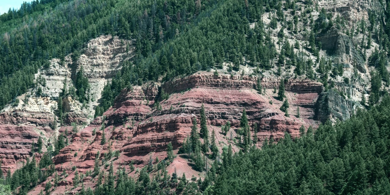
Named after the placer gold mines situated on the San Miguel River and Leopard Creek, Placerville got its start as a mining camp in the late 1800s. By 1919, there were at least five mines in the town, which produced 30% of the world’s vanadium, with over 3 million pounds produced through 1940.

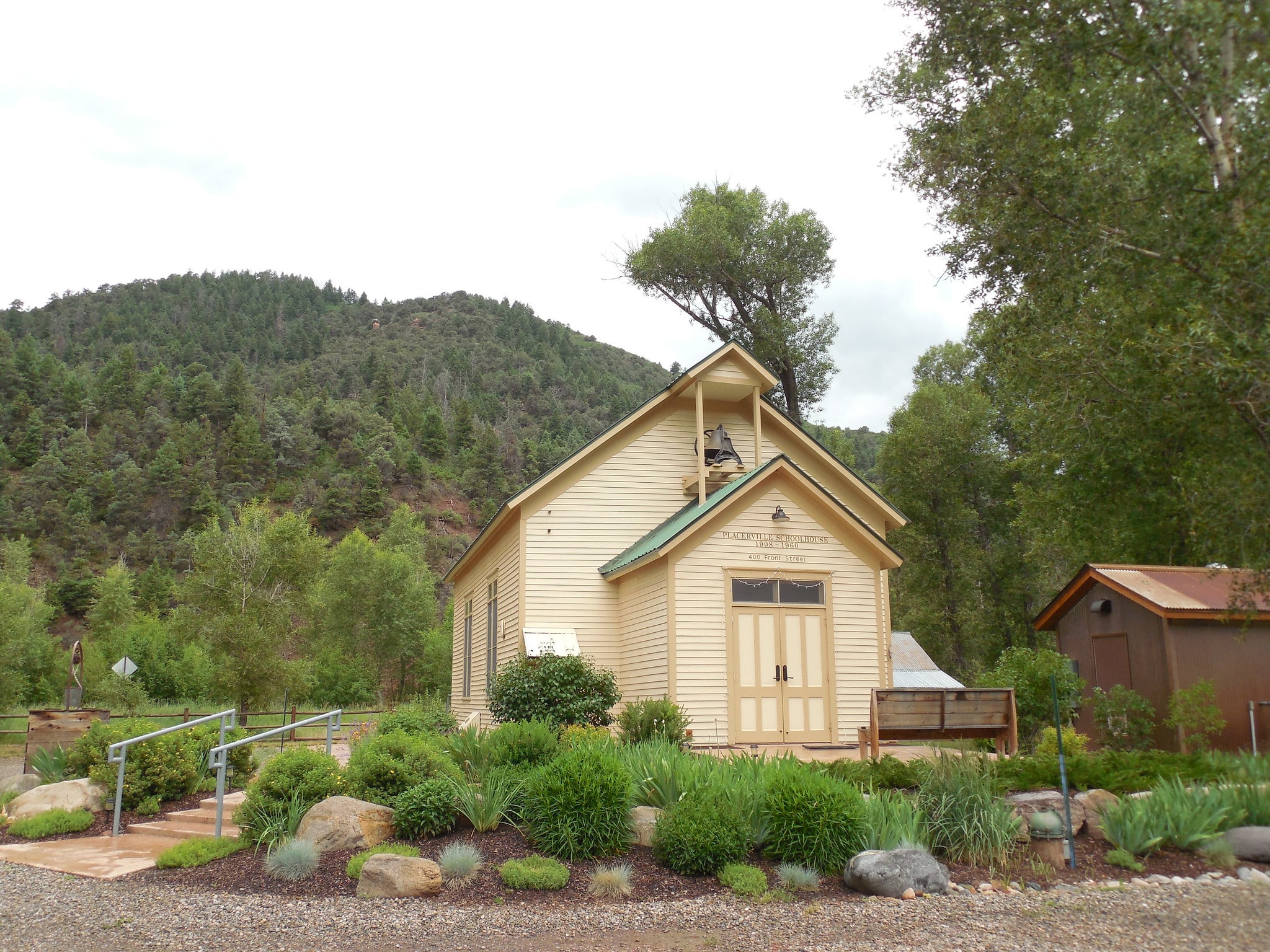
A small schoolhouse operated for over 50 years in the early 1900s, eventually closing down in 1960. It is still standing today in Placerville Park, serving as a group gathering place for events.

Recreation

Red river running next to highway
The San Miguel River near Placerville. Photo by: Chuckcars

Camping –

  • Caddis Flats Campground is located right off the Unaweep Tabeguache Byway and has 3 developed campsites, one of which has a cabana for shade.
  • Fall Creek Recreation Site has 4 campsites spread around, with a covered picnic table and a small grill in the center. It is primitive camping, so don’t expect any electrical hookups. It is situated right on Fall Creek, so you’ll have some nice babbling white noise during your stay.
  • Read about the camping near Telluride, Ophir and Rico.

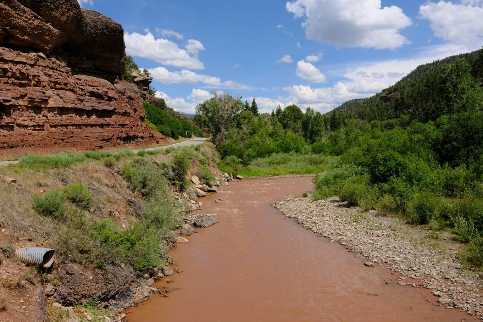
Fishing – The San Miguel River is a pretty good coldwater river to catch trout, mostly rainbow and cutthroat (and the occasional cutbow).

Hiking –

  • Placerville Park is a beautiful community park with several trails that go around the pond and then shoot off into a small system along the river. There are public restrooms, and accessible parking spots, plus visitors can also fish the waters.
  • Alder Creek trailhead is about 45 minutes from town heading east towards Telluride. It totals 6.5 miles, leading into the Mount Sneffels Wilderness. Views of Hayden Peak are unmatched and even more beautiful in the autumn months.
  • The Deep Creek trailhead is on the way to Alder Creek and also has breathtaking views of the surrounding mountain range and the Uncompaghre National Forest. Wander out for as many miles as you feel like, and if you continue on it will eventually lead to Telluride Village after about 14 miles.

Accommodations

Two people sitting in leather armchairs in a living room of the hostel
Common area at The Bivvi Hostel Telluride, near Placerville. Photo by: facebook.com/thebivvihostel


Booking.com

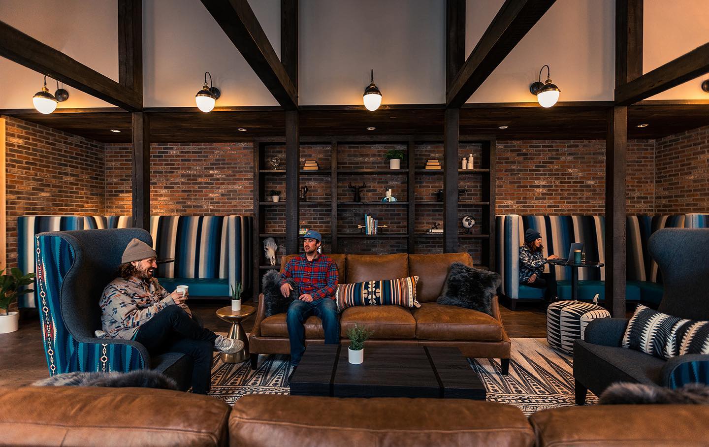
The Bivvi Hostel Telluride – Right smack in the middle of a picture-perfect adventuring hub, this hostel is a great gathering place for any type of traveler. In addition to traditional hostel-style dorms with bunk beds, Bivvi also offers private suites that sleep up to 4. There is a hot tub, pool table, gear room, and plenty of common areas to relax after a fun-filled day.

If you’re looking for more options, head 25 minutes east to check out the best hotels in Telluride.

Activities near Placerville

Dog Sledding: 

  • Wintermoon Sled Dog Adventures

Federal Lands:

  • San Juan National Forest
  • San Miguel River
  • Uncompahgre National Forest

Hot Springs:

  • Orvis Hot Springs (25mi)
  • Ouray Hot Springs Pool (33mi)
  • Rico Hot Springs (closed) (36mi)

Scenic Drives:

  • Dallas Divide
  • San Juan Skyway
  • Unaweep Tabeguache Byway

Ski Areas:

  • Telluride Ski Resort (16mi)

State Parks:

  • Ridgway State Park (29mi)

Towns:

  • Gateway
  • Montrose (50mi)
  • Mountain Village (7mi)
  • Naturita (36mi)
  • Norwood (17mi)
  • Nucla (41mi)
  • Ophir (21mi)
  • Ouray (34mi)
  • Redvale (26mi)
  • Rico (36mi)
  • Ridgway (23mi)
  • Sawpit (3mi)
  • Telluride (15mi)
  • Uravan (54mi)

Transportation:

  • Montrose Regional Airport (MTJ) (52mi)
  • Telluride Regional Airport (TEX) (14mi)

Waterfalls:

  • Bridal Veil Falls (18mi)
  • Mystic Falls (16mi)

Whitewater Rafting:

  • San Miguel River Rafting

Latest in Placerville

Camping near Telluride CO Alta Lakes Evening

Camping near Telluride, Ophir and Rico

Telluride is one of Colorado’s most beloved mountain towns and most secluded. Throughout the warmer spring,…

Camping near Telluride, Ophir and RicoRead More

View more Placerville articles

Primary Sidebar

Join our Colorado travel community

Enter your email below and grab our free locals' guide and monthly what's up designed to help you live your Colorado life and uncover fun things to do. —and never miss out again.

San Miguel County

  • All Towns
  • San Miguel County
  • Ames
  • Egnar
  • Mountain Village
  • Norwood
  • Ophir
  • Placerville
  • Sawpit
  • Telluride

Footer

Get In Touch

  • Home
  • About Us
  • Contact Us
  • Privacy Policy
  • Resources
  • Disclaimer—Terms of Service
Facebook Instagram Pinterest Twitter

Disclosure: Uncover Colorado is a participant in the Amazon Services LLC Associates Program, an affiliate advertising program designed to provide a means for sites to earn advertising fees by advertising and linking to Amazon.com.

Things To Do

  • Travel Blog
  • Colorado Activities
  • Colorado Events
  • Colorado Towns
  • Colorado Hotels
  • Colorado Restaurants
  • Colorado Transportation
  • Made in Colorado

Cheers! Mile High Happy Hour shares showcases Denver neighborhoods' restaurant happy hours.

Fall Activities

  • Camping
  • Federal Lands
  • Ghost Towns
  • Hot Springs
  • Landmarks
  • Ski Resorts
  • State Parks
  • Train Rides

Copyright © 2023 · Uncover Colorado | Sitemap | Advertise